
More than 2,400 3,400 4,400 people are dead as a result of an earthquake that struck Nepal just before noon, local time, on April 25, the BBC reports. About 5,900 people were injured in the earthquake.
Reports said the 7.8-magnitude quake struck an area of central Nepal between Katmandu and the city of Pokhara early on Saturday, according to the BBC. A map published by the New York Times shows the location more precisely.
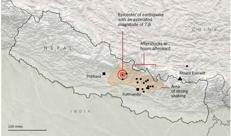
A growing sense of despair spread through Katmandu on Sunday, as the already-devastated Nepali capital felt aftershocks, which caused many residents to scream into the streets during a heavy rain, the New York Times reported.
Why did the earthquake happen?
According to Dr Brian Baptie, head of seismology at the British Geological Survey in Edinburgh, two tectonic plates meet beneath the Himalayas along a fault line: the India plate and the Eurasia plate.
The India plate moves north about 45 mm per year and pushes under the Eurasia plate, he told Al Jazeera. Over time, that’s how the Himalayas, the tallest mountains in the world, were created out of what was thought to be a string of islands before the two plates met.
The fault, where the India and Eurasia plates meet along the 2,200-km Himalayan range, also gives rise to one of the world’s most active earthquake zones, as the two plates collide about 15 km beneath the Earth’s surface.
These collisions not only cause earthquakes like the one Saturday and aftershocks, but they also push the height of the peaks up by a few centimeters each year. The exact increase in elevation is in dispute: estimates vary from 0.16 inches, or 0.4 cm, to 6.1 cm, or 2.4 inches.
“The collision between India and Eurasia is a showcase for geology,” the Wall Street Journal quoted Lung S Chan, a geophysicist at the University of Hong Kong, as saying. “Geologically speaking,” he said, the rate at which the India plate is pushing northward against the Eurasia plate is “very fast.”