
The national parks of Southern Utah include Bryce Canyon with its intricate spires and formations, but many of those can be found in the nearby Cedar Breaks National Monument, a naturally carved amphitheater that the early Paiute people called the “circle of painted cliffs.”

Hoodoos in the amphitheater, from the northern overlook at Cedar Breaks (Voxitatis)
Hoodoos are formed by two weathering forces that work on the rocks simultaneously: First, frost wedging, along with possibly hundreds of freeze-thaw cycles every year here at 10,000 feet, allows melting snow to seep into the cracks of the plateau that gives me footing around the rim of the amphitheater. As the water freezes at night, it expands by almost 10 percent and pries open cracks in the rocks. This makes the cracks wider, little by little, similar to the way a pothole keeps getting bigger in a road.
Second, a small amount of weakly acidic rain, with its carbonic acid that can dissolve limestone grain by grain, falls on the amphitheater. This is what makes the edges of the hoodoos round and makes the hoodoos look lumpy. The rain also erodes the hoodoos, especially the high-intensity monsoons that sometimes happen during the summer.
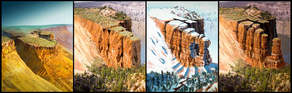
These weathering forces are still at work today and will eventually cause the hoodoos to disappear, even as others may form. But it started when the area was still just part of the Markagunt Plateau. As the weathering removed the sides, it became a fin.

Fins are getting thinner and thinner.
Then, as if we were looking at a distant galaxy to see how galaxies are formed, we note, in this very same amphitheater, windows and arches that form on the way, potentially, to becoming a hoodoo.

When the arch can no longer support the weight of its own roof, a hoodoo might form. Brian B Roanhorse of the National Park Service created a diagram to illustrate the process from plateau to hoodoo: