There was good news and bad news about the ice covering the Arctic Ocean as this year’s melting season came to a close on Sept 18. And whether it’s good or bad depends on how well you read it.
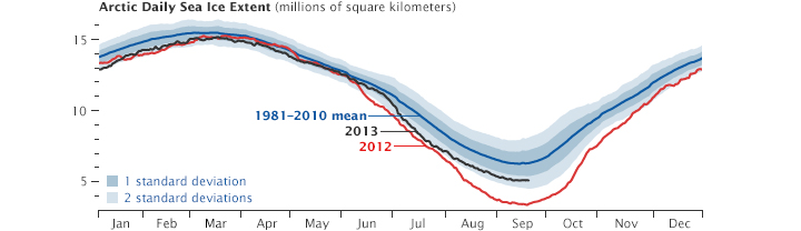
In the above graphic, note the axes don’t intersect at y=0. Don’t be misled by that.
First the good news: The extent of the coverage of the ice is substantially greater now than it was at the end of the 2012 melting season. Reports called the increase over last year’s minimum “60 percent.” That sounds good, but our joy is dampened by knowing that last year’s melting produced the lowest extent ever recorded. Furthermore, the extent of the Arctic ice is still on a downward trend over multiple years.
Climate-warming skeptics—see the Fox News report, here, which has concluded that this is evidence of global cooling and makes other laughably scientific claims—relish in pointing to factoids like the one above, which is technically true, although the 60 percent number may be a small exaggeration.
How much of an exaggeration it is depends on the actual numbers, but a change in wind or weather patterns could cause additional melting. The numbers for this come from the National Snow & Ice Data Center, which reported last week that the ice had reached a minimum for the year:
This year’s minimum was 1.69 million square kilometers (653,000 square miles) above the record minimum extent in the satellite era, which occurred on September 16, 2012, and 1.12 million square kilometers (432,000 square miles) below the 1981 to 2010 average minimum.
So, in computing the extent of the exaggeration of “60 percent greater than last year’s minimum,” we look at the actual numbers. On Sept 18, 2013, 5.10 million square kilometers (1.97 million square miles) were covered by Arctic sea ice, compared to 3.41 square kilometers on Sept 16, 2012. That gives us a difference of 1.69 million square kilometers, as computed by NSIDC above, which is about 49.6 percent of last year’s minimum. It should have been rounded to 50, but it’s still quite a bit higher than last year’s minimum.
A report in the Guardian says most climate scientists were predicting there would be more sea ice this year than last year anyway. Last year’s record low, you see, was a sign of a trend, but the extremely low value wasn’t sustainable. This led more than 80 percent of about a hundred scientists who attended the Bjerknes Arctic Climate Science Conference to predict an increase this year, which was, in fact, observed.
This kind of reversal has happened before, however, usually following then-record lows, but the multi-year trend for ice extent is still sloping downward, as an animated graph in the Guardian’s article, here, nicely illustrates.
Now, for the bad news. Actually, there are two bits of bad news here:
- The thickness of the ice is low
- Global temperatures are heating up
Satellite data (from NASA) shows that the thickness of the Arctic ice is at a record low. This means the actual volume of the ice might be less than last year, despite the fact that new ice (less than a year old) covers more area than last year. NASA writes:
The Arctic sea ice cover today is much thinner on average than it was years ago. Satellite imagery, submarine sonar measurements, and data collected from NASA’s Operation IceBridge indicate that the sea ice thickness is as much as 50 percent thinner than in previous decades, going from an average thickness of 3.8 meters (12.5 feet) in 1980 to 1.9 meters (6.2 feet) in recent years. Older, thicker ice is being replaced by thinner, seasonal ice.
Most of the Arctic Ocean used to be covered by multiyear ice, or ice that has survived at least two summers and is typically 3 to 4 meters (10 to 13 feet) thick. This older ice has declined at an even faster rate than younger ice and is now largely relegated to a strip along the northern coast of Greenland. The rest of the Arctic Ocean is dominated by first year ice, or ice that formed over the previous winter and is only 1 to 2 meters (3 to 7 feet) thick.
Plus, the air temperatures on Earth are heating up, which might make the oceans heat up (even more) and melt more ice next year, surpassing last year’s record low. This summer was the 15th hottest on record in the US, the National Oceanographic and Atmospheric Administration reported. It was our coolest summer since 2009 but still 1.2 degrees Fahrenheit above the 20th-century average.
In addition, Greenland is getting warmer, NOAA says. The Danish Meteorological Institute reported a temperature of 25.9°C (79°F) on the afternoon of July 30 at the Maniitsoq/Sugar Loaf airport, the highest temperature ever recorded in Greenland.